


Macedonia Masonic Hall, Pickens County, Alabama
About
Outline

Summary
| Unique Area Identifier | 522786 |
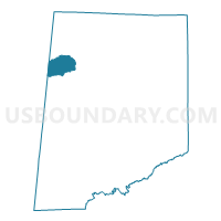
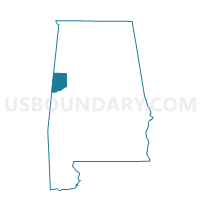
| Name | Macedonia Masonic Hall |
| County | Pickens County |
| State | Alabama |
| Area (square miles) | 15.03 |
| Land Area (square miles) | 15.02 |
| Water Area (square miles) | 0.01 |
| % of Land Area | 99.91 |
| % of Water Area | 0.09 |
| Latitude of the Internal Point | 33.38753580 |
| Longtitude of the Internal Point | -88.26860530 |
Maps

Graphs
Select a template below for downloading or customizing gragh for Macedonia Masonic Hall, Pickens County, Alabama


Neighbors
Neighoring Voting District (by Name) Neighboring Voting District on the Map
- Ethelsville City Hall, Pickens County, AL
- McShan Comm Center, Pickens County, AL
- New Hope C Voting District, Lowndes County, MS
- Pine Grove 1 Community Center, Pickens County, AL
- Pine Grove 4 Comm Center, Pickens County, AL
Top 10 Neighboring County Subdivision (by Population) Neighboring County Subdivision on the Map
Top 10 Neighboring Place (by Population) Neighboring Place on the Map
Top 10 Neighboring Unified School District (by Population) Neighboring Unified School District on the Map
Top 10 Neighboring State Legislative District Lower Chamber (by Population) Neighboring State Legislative District Lower Chamber on the Map
Top 10 Neighboring State Legislative District Upper Chamber (by Population) Neighboring State Legislative District Upper Chamber on the Map
Top 10 Neighboring 111th Congressional District (by Population) Neighboring 111th Congressional District on the Map
- Congressional District 1, MS (788,095)
- Congressional District 4, AL (660,162)
- Congressional District 7, AL (603,352)